

Improving weather forecasts with solar satellite images
23.06.2023
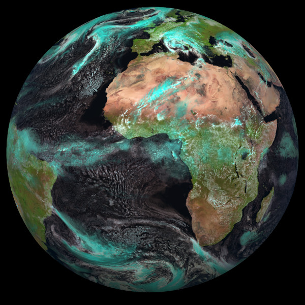 Synthetic satellite image computed with MFASIS-NN from forecast of the ICON model for the SEVIRI instrument onboard Meteosat MSG-4. For the red, green and blue components of this image we used the satellite channels at wavelengths of 1.6, 0.8 and 0.6 micron, respectively.
The first weather satellites in the 1960s already provided images in the solar spectral range, where sunlight reflected from the Earth is measured. These images contain a wealth of information about the spatial distribution of clouds, their water and ice content, as well as properties such as the mean droplet size. Since March 2023, such satellite images have been directly utilized by the German Weather Service (Deutscher Wetterdienst) for the purpose of improving operational weather forecasting. Developments at the Meteorological Institute of LMU (Ludwig Maximilians University) have played a crucial role in this success. Enhancing the forecast requires a forward operator, which means a method to generate a synthetic satellite image from a numerical weather forecast. By analyzing the differences between the observed and synthetic images, data assimilation techniques can determine how the model state needs to be corrected in order to improve the next forecast. Generating synthetic images using standard methods is particularly demanding and time-consuming in the solar domain, making it impractical for operational weather forecasting. Within the framework of the virtual Hans-Ertel Institute for Weather Research, methods have been developed at LMU in collaboration with the German Weather Service that are orders of magnitude faster. With the latest version, "MFASIS-NN" (Baur et al. 2023), which is based on neural networks, images in the near-infrared spectral range can now be efficiently computed, in addition to visible ones. The near-infrared images contain additional information that allows, among other things, distinguishing between water and ice clouds, which should lead to further improvements in the forecasts. Shown above is a synthetic image calculated using the new method for the SEVIRI instrument on the geostationary weather satellite Meteosat MSG-11. By combining visible and near-infrared observations, water clouds appear white, while ice clouds appear bluish.