Project IcePolCKa: polarimetric radar observations
17.01.2019
![]() The IcePolCKa project, part of the DFG Priority Programme 2115 (PROM), has started mid January 2019.
The IcePolCKa project, part of the DFG Priority Programme 2115 (PROM), has started mid January 2019.
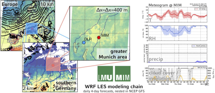
Aim of the project is to exploit the synergy of two full polarimetric radars, the C-band POLDIRAD at DLR, Oberpfaffenhofen and the Ka-band MIRA-35 at LMU, Munich, to study convective initiation as well as ice particle growth and its role in precipitation formation. Being almost perfectly aligned along the average wind direction and thunderstorm path in this area, this setup allows tracking convective and stratiform clouds for a significant fraction of their lifetime. Observations will be aided by data from the DWD weather radar network and the research radar at DWD Hohenpeißenberg. Numerical modeling using a nested WRF high-resolution weather model setup will allow to analyze the performance of microphysics parameterizations with varying levels of complexity.
The representation of microphysical processes in numerical weather models is a main source of uncertainty. Due to operational constraints models run at insufficient resolution and use strongly simplified parameterizations. Important parameters like the conversion between different microphysics classes or details of ice particle growth are hard to observe with standard techniques. Novel observations are needed to evaluate and improve these parameterizations at the level of detail currently in use in numerical models. Observations have to provide variables that form the basis of current parameterizations, e.g. predominant hydrometeor class and conversion rates, spatial distributions of dominant cloud particle sizes, and typical timescales in cloud development. Special focus should be given to the onset and evolution of cold rain processes, since a significant fraction of precipitation in the mid-latitudes develops via the ice phase.
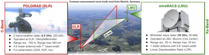
At a distance of 23 km between DLR and LMU the use of the two research radar systems allows targeted observations and coordinated scan patterns, while area coverage and larger spatial context will be provided by the DWD C-band weather radars. In order to study life-cycles of convective cells or precipitation development (e.g. fall streaks), object tracking will be applied using horizontal PPI and vertical RHI cross sections on or close to the line-of-sight. An ice particle size retrieval will be developed for the dual-wavelength radar measurements, which will be used to advance established polarimetric hydrometeor classifications. Other processes observable will be drizzle formation, cloud glaciation, distinction between depositional growth of small ice particles, onset of quicker ice particle growth into precipitation sized particles by aggregation, and initiation of first precipitation at the surface. Timing of these processes and their spatial distribution will be observed and compared to modeled processes. Using a numerical weather model (WRF) with a nested domain centered over Munich at high spatial resolution (∆x of around 100 m), we will analyze how microphysical parameterizations of different levels of complexity compare to the observations.