

Verbesserung der Wettervorhersage durch Assimilation sichtbarer Satellitenbilder
23.06.2020
Verbesserung der Wettervorhersage durch Assimilation sichtbarer Satellitenbilder
Beobachtungen von Instrumenten auf geostationären Satelliten sind eine vielversprechende Informationsquelle für die Datenassimilation auf konvektiven Skalen, deren Ziel verbesserte regionale Vorhersagen sind. Bisher wurden nur Infrarot- und Mikrowellen-Beobachtungen direkt assimiliert, und das oft auch nur in wolkenfreien Gebieten. Nicht benutzt wurden dagegen Satellitenbilder im sichtbaren Spektralbereich, die Informationen über die Position und Größe von Wolken sowie deren mikrophysikalische Eigenschaften, wie z.B. die mittleren Tröpfchengrößen enthalten. Der Hauptgrund dafür war, dass eine für die Assimilation benötigte, schnelle und genaue Methode zur Erzeugung synthetischer Satellitenbilder aus Modelldaten fehlte. Mit der Entwicklung einer geigneten Methode im Teilbereich Datenassimilation des Hans-Ertel-Zentrums für Wetterforschung ist es nun möglich geworden, sichtbare Satellitenbilder operationell zu assimilieren.
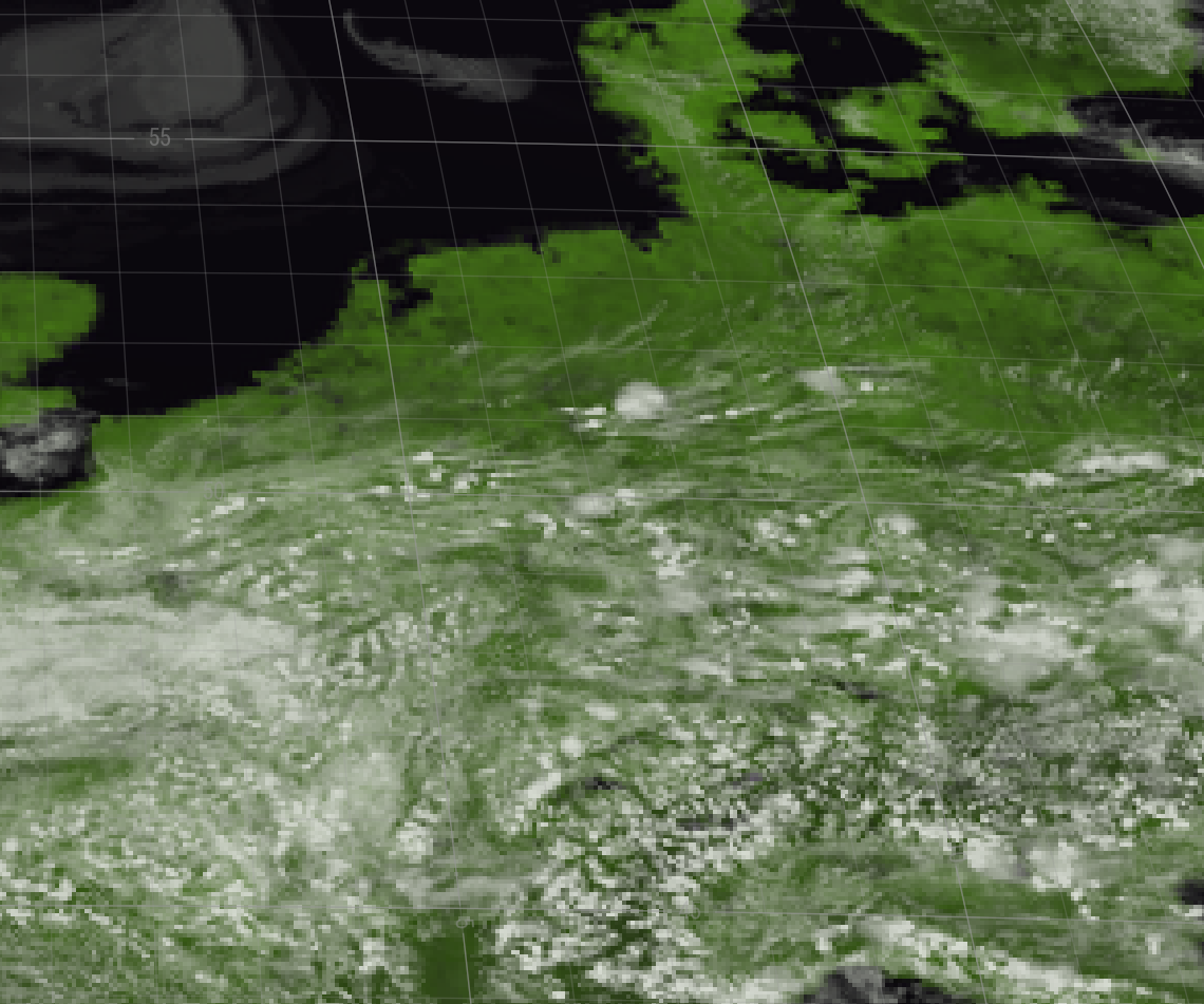
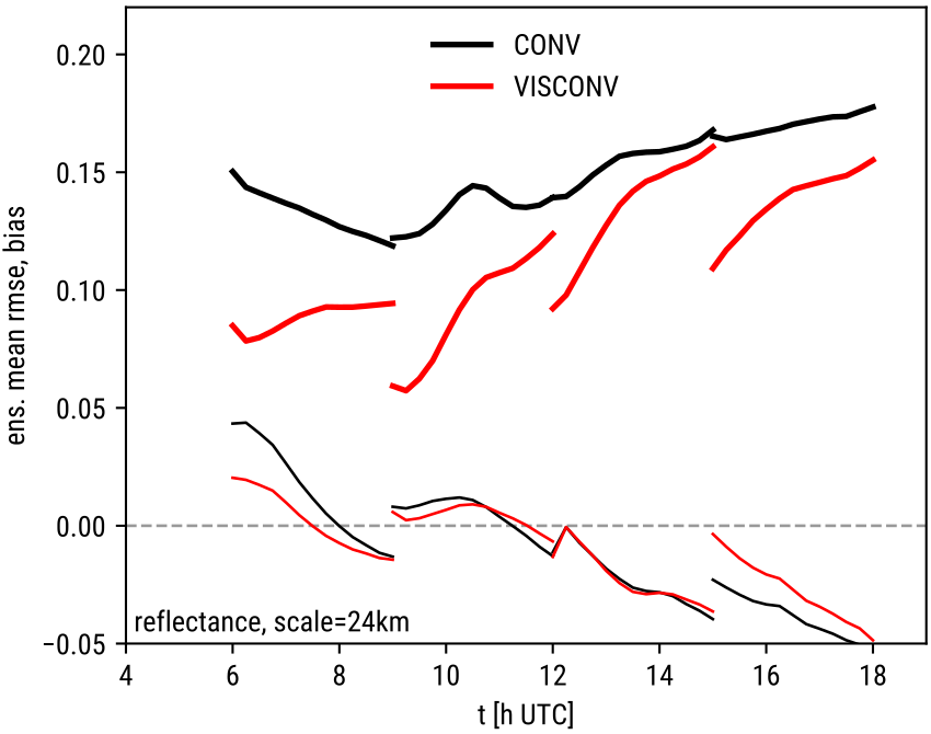
Eine erste Fallstudie dazu wurde nun publiziert. Für die Studie wurde das COSMO-Vorhersagemodell und das KENDA-Datenassimilationssystem genutzt, das beim Deutschen Wetterdienst entwickelt wurde. Für zwei konvektive Tage im Sommer 2016 wurden zwei Experimente verglichen, eins, in für das nur konventionelle Beobachtungen benutzt wurden und ein zweites, in dem zusätzliche sichtbare 0.6µm Satellitenbilder des SEVIRI-Instrument auf Meteosat-10 assimiliert wurden. Die linke Abbildung zeigt ein synthetisches Satellitenbild von Deutschland, das im Rahmen des Assimilationsprozesses aus COSMO-DE-Modelldaten erzeugt wurde. Die Hauptergebnisse der Studie sind, dass Fehler in der Wolkenverteilung durch die Datenassimilation stark reduziert werden können, dass diese Verbesserung in den Vorhersagen mindestens 3 Stunden lang erhalten bleiben und dass auch die Niederschlags-Vorhersagen verbessert werden. Die Verbesserungen in der Bewölkungs-Vorhersage werden illustriert durch die rechte Abbildung, die den Reflektanz-Fehler (RMSE, dicke Linien) und Bias (dünne Linien) für das Experiment ohne (schwarz) und mit (rot) Satellitenbildern für 3-Stunden-Vorhersagen zeigt, die für den 5. Juni 2016 um 6, 9, 12 and 15 UTC gestartet wurden. Diese Verbesserungen in der Wolkenvorhersage sind auch relevant für die Leistungsvorhersage von Photovoltaik-Anlagen, die derzeit in einem weiteren Projekt untersucht wird.
Scheck, L., Weissmann, M. and Bach, L. (2020), Assimilating visible satellite images for convective scale numerical weather prediction: A case study. QJR Meteorol Soc., accepted. https://doi.org/10.1002/qj.3840